


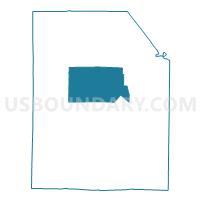
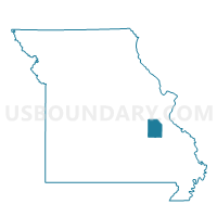
Ebo Voting District, Washington County, Missouri
About
Outline

Summary
| Unique Area Identifier | 611540 |
| Name | Ebo Voting District |
| County | Washington County |
| State | Missouri |
| Area (square miles) | 62.81 |
| Land Area (square miles) | 62.65 |
| Water Area (square miles) | 0.16 |
| % of Land Area | 99.75 |
| % of Water Area | 0.25 |
| Latitude of the Internal Point | 38.00499860 |
| Longtitude of the Internal Point | -90.91251610 |
Maps

Graphs
Select a template below for downloading or customizing gragh for Ebo Voting District, Washington County, Missouri


Neighbors
Neighoring Voting District (by Name) Neighboring Voting District on the Map
- Algire Voting District, Washington County, MO
- Courthouse Ward I, Washington County, MO
- Cruise Voting District, Washington County, MO
- Old Mines Voting District, Washington County, MO
- Richwoods Voting District, Washington County, MO
- Shirley Voting District, Washington County, MO
Top 10 Neighboring County Subdivision (by Population) Neighboring County Subdivision on the Map
- Breton township, Washington County, MO (10,326)
- Union township, Washington County, MO (3,107)
- Richwoods township, Washington County, MO (1,581)
- Kingston township, Washington County, MO (1,553)
- Liberty township, Washington County, MO (1,508)
- Johnson township, Washington County, MO (1,190)
- Walton township, Washington County, MO (893)
Top 10 Neighboring Unified School District (by Population) Neighboring Unified School District on the Map
- Potosi R-III School District, MO (13,408)
- Crawford County R-I School District, MO (6,249)
- Kingston K-14 School District, MO (4,898)